By THAN HTUN (GEOSCIENCE MYANMAR)
EPISODE: 55
The Southern Volcanic Occurrences on the West Bank of the Chindwin River.
This article continues from Episode 54, which discussed the explosive craters on both banks of the Chindwin River, as described in The Geology of Burma by Prof HL Chhibber, published in 1934.
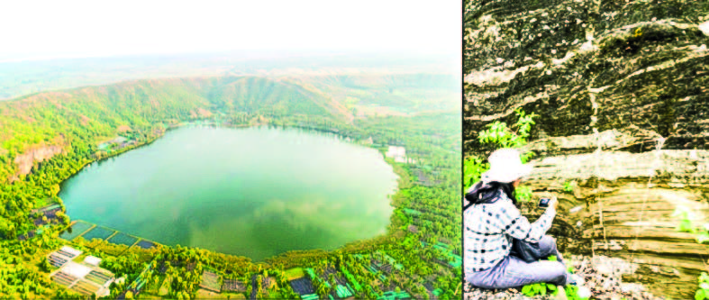
Songyaung: On the right bank of the Chindwin River, opposite Alon and two miles east of Songyaung, is a low hill extending in a north-west-south-east direction, with gentle slopes on all sides except the north, where it ends abruptly over a shallow lake, with a scarp about 100 feet in height. This lake is deeply truncated near the northeastern side and marks the site of an extinct crater. That part of the hill that abuts the river, according to Sondhi, is composed of highly jointed, comparatively fresh, dark, olivine basalt. A little way from the river, the basalt becomes highly scoriaceous and vesicular. Farther west, it is replaced by a very characteristic bed, about six feet thick, of lapilli cemented by a sparse amount of volcanic ash. To the southwest of the lapilli bed occur several unconsolidated beds of basaltic tuff, with many quartz pebbles, sand, and fossil wood.
Kyaukmyet Hill: The Kyaukmyet hills are composed of very compact rhyolites and quartz-porphyries with interbedded quartzites. A liparite from this locality was first described by Kelterborn. It is a dense rock that shows some iron pyrites and biotite to the naked eye. The microscope reveals the biotite to be corroded with the formation of opaque ore, while sections of corroded quartz are also present. The groundmass is micro-felsitic and consists of quartz and slightly turbid felspar. The texture must originally have been vesicular, but the cavities are now all filled with a coarse-grained quartz mosaic. Hydrothermal silicification must have brought about this after the consolidation of the rock.
Myayeik Taung: The main hill is composed of silicified rhyolite with blocks of quartzite, while the small hill to the west is built of shattered quartzite and highly altered basalt. In the Yinmadaw chaung (creek) to the southwest are masses of epidiorite, which appear to rest against a decomposed holocrystalline rock composed of white felspar and small black biotite crystals. East of Myayeik there is another small hill of purple quartz-porphyry.
West Monywa Group: The conical-shaped hills 994,943 and 937, immediately south of Yama chaung, and hills 1055 and 995, five miles to the south-east and on the south side of the Ywashe-Yinmabin road, which is so prominent in the landscape looking southwards from Monywa, are composed of white and bluish-grey rhyolites, rhyolitic breccias, agglomerates and indurated tuffs. They have undergone hydrothermal and metasomatic alteration. Haematite occurs in the form of veins and botryoidal masses in these rocks. The ores of copper, malachite, and azurite are also present in the form of veinlets and impregnations. Exploitation of the copper ore has been attempted by shafts and tunnels sunk into the volcanic rock, but the ore occurs in quantities too minute to be won on a commercial scale.
Ninth Mile, Yinmabin Road: Just past the ninth mile on the Ywashe-Yinmabin Road, where the road commences the descent to the village of Kaungzin, are outcrops of an interesting rock that seems to differ from all others in the Chindwin region. It is a glassy hypersthene-andesite in which phenocrysts of andesine-labradorite felspar and hypersthene are observed in thin sections. A few miles farther south are the igneous occurrences of the Ingyin taung and Powin taung area, which consist of andesites, rhyolitic agglomerates, and fine-grained ashes and tuffs interbedded with the Pegu Series, and intrusions of coarse diorites and mica-porphyries. The andesites have locally been silicified and the vesicles of the amygdaloidal rock have been filled with chalcedony in beautifully radiating fibres. The ashes and tuffs have undergone pronounced metamorphism brought about most probably by the intrusion of adjacent diorites.
Salingyi: According to C T Barber, the intrusive and extrusive rocks of the Salingyi uplands consist of dacites, dolerites, epidiorites, and coarse-grained diorites. There also occurs an intrusion of granitic rock into typical dolerites in the neighbourhood of Saga (95˚ 8’, 21˚57’) and the intrusion of a pegmatite dyke into coarse diorite one and a half miles south-east of Kyaunggon (95˚ 6’, 21˚ 58’). Barber adds, moreover, that the general configuration and petrological characters of the igneous masses are such as to leave little doubt that they were formed as laccolitic intrusions into the Pegus, the sedimentary cover having been removed by denudation.
Linzayet: At Linzayet eight and a half miles to the south of Salingyi is a small mass of lava, a hundred feet or so in diameter, which also to have been appeared to have been intruded into sands of Pegu age, chiastolite developed near the contact. The Pegu rocks dip towards this intrusion at steep angles. This occurrence is of a similar type to Hill 1260, and the other intrusions in the East Monywa Hill Belt, described below.
Shinmadaung: The volcanic rocks of the Shinmadaung area consist of hornblende-andesite, basalts, ashes, and rhyolitic agglomerates and breccias. Occurring immediately beneath the basal read bed of the Irrawaddy Series on the west flank of the Shinmadaung inlier, west of Kabauk village, are to be found conglomerates and rhyolite breccia. Some doubt exists as to the age of these rocks, but according to E S Pinfold and A E Day, they appear to represent a period of specialized volcanic activity contemporaneous with the deposition of the basal beds of the Irrawaddian, while Barber states that they occupy along the Pegu-Irrawaddian boundary and that the presence of ashes and rhyolitic agglomerates interbedded in the Pegu Series has been clearly demonstrated.
There are, in addition, small intrusions of a doleritic rock in beds of Pondaung age, which are exposed in this inlier. They also occur mainly along the line of the strike fault. One of the most interesting volcanic occurrences in this range, also on the line of the main strike fault, is a sheet of lava forming a high plateau-like elevation to the north of Thayet-pingan, which recalls the Silaung sheet described above.
The Volcanic Occurrences of East Monywa Hill Belt.
The volcanic occurrences in this belt from south to north are as follows: -
Hill 1260, or Kyaukkadaung (22˚ 8’, 98˚ 6’): The hill is situated about nine miles east and a little north of Monywa, and occurs close to the western flank of the Pegu inlier. It is elliptical in shape, the longer axis of the ellipse running a few degrees north of east. There are three blunted peaks, the centre or highest rising some 800 feet above the alluvial plain, which stretches away to the west. The core of the hill is composed of a very basic basalt, surrounded by Pegu rocks, and appears to lie on the line of the main fault, which is evident to the south on the west side of Taunggya village. The extent of the actual mass of the igneous rock is about a mile in length and a quarter of a mile in width.
Hill 779 (22˚ 13’, 95˚ 18’): This intrusion of igneous rock lies about seven miles to the northeast of Hill 1260, on the south bank of the Thazi chaung between the villages of Thazi and Sulegon. The igneous mass is elliptical, with the longer axis running a few degrees west of north, and is thus slightly oblique to the Pegu sands, in which it occurs and which strike about north 10˚ east. It is situated well within the Pegu inlier, some three miles east of the main fault. It is half a mile in length and quite narrow. Petrologically, both the Kyaukkataung, 1260 Hill, and the Hill marked 779 are composed of picrite-basalt, which is a greyish rock, sometimes spotted with phenocrysts of pyroxene and olivine.
Hill 822, or Thazi Hill (22˚ 17’, 95˚ 15’): This occurrence of igneous rock is conical in shape and lies on the line of the main fault on the edge of the Pegu inlier, apparently within Pegu sands, Irrawaddy sands, and alluvium. The lava of Thazi Hill has also been described as picrite-basalt, though less basic than that of Hill 1260, but not widely differing from it. It is a dark grey rock. The most abundant mineral under the microscope is augite, varying in size from small phenocrysts to granules in the groundmass. The latter resembles that of the normal rock of Hill 1260, consisting of laths and microlites of felspar, small crystals and granules of augite, grains of magnetite, and a colourless residue. Some of the vesicles are filled with calcite.
Inde Hill, 800 feet (22˚ 24’, 95˚ 13’): This is the most interesting occurrence within the hill belt, as it bears visible evidence as a centre of volcanic activity: remnants of a crater and deposits of volcanic ash occur, similar in every way to the deposits accompanying the explosive craters about Shwezaye. It can be included as one of the groups as its age and mode of occurrence are identical, but instead of appearing on the same lines as the other craters, it is situated 10 ½ miles to the east of Ywatha, the northernmost of the group, and occurs on the line of the main fault which runs the length of the East Monywa Pegu inlier. The village of Inde rests upon a narrow belt of alluvium, but immediately to the south are beds of volcanic ash which curve round to the spur of Hill 800. In a stream bed about one mile south of the village beds of ash rest upon sands apparently of Irrawaddian age. These deposits of ash are from 10 to 15 feet thick and consist of layers of coarse lapilli between much finer material. In the coarse layers are occasional blocks of lava up to a foot in diameter. These beds are not consolidated, and where they overhang the walls of the chaung they break into heaps of grey cindery powder. The ash deposits on the spur to the north of Hill 800 rest upon Irrawaddian sands, and farther north, where the ash beds have died out, blocks of lava can still be seen strewn about the surface of the sands and extend thus as far as the stream bed to the north-east of Myothit Chaung village.
The inward slopes of Hill 800 and spur present a precipitous face which is evidently a remnant of the crater walls. The northern and western walls have been removed by denudation and the floor is now silted up. The lava ejected from this crater is a normal olivine-basalt with phenocrysts of olivine, rendered opaque red by oxidation on the exposed surface of the rock. The eruptions of this crater were apparently of the explosive type, but the successive layers of coarse ash and fine material throughout the thickness of deposits point to a series of explosive eruptions extending over a while rather than to one violently explosive outburst. The age of this volcano is clearly sub-recent, as is proved by the deposition of the ejected material upon the uppermost Irrawaddian sands.
Okpo Letpan (22˚ 29’, 95˚ 14’): Okpo Letpan is an isolated hump-shaped hill standing 400 feet above the level of the surrounding plain, which is floored by sands of Irrawaddian age. The hill lies about seven miles north of Inde and three miles north by northeast of the volcanic bed at the twenty-sixth milestone described above. The lava is much decomposed at the surface and can be dug into with a knife blade; it differs from the igneous rocks of the other occurrences, except those of Hill 800 and the twenty-sixth milestone just described, in that it contains visible phenocrysts of white felspar.
The Natyindaung Mass: Natyindaung (22˚ 30’, 94˚ 59’) is an isolated occurrence of igneous rock, unassociated with the East Monywa Hill belt inlier, lying some distance to the west, in an area floored by the uppermost Irrawaddian sands. It is of special interest as contact with the soft sands can be seen. It closely resembles Okpo Letpan in shape, occurring as two hump-shaped hills with an intermediate depression.
Conclusion
A large majority of the igneous occurrences of this region indicate that volcanic activity reached its zenith in post-Pliocene times. The peculiar masses of Hills 1260, 779, 822, Okpo Letpan, and Natyindaung, all appear to have intruded into the country rock, both Peguan and Irrawaddian alike, as sheets or necks. Previous to the recent district examination by Messrs E S Pinfold and A E Day, it was thought that pre-Cambrian granites and Shinmadaung, the pre-Tertiary floor, were exposed in this region. Except for the isolated occurrences of granite at Silaung and Minma, the majority of the holocrystalline rocks belong to a peculiarly basic suite, and there is small doubt that they are the hypabyssal representatives of the surface lavas, intruded into the Tertiary rocks at the same time as the volcanic manifestations at the surface. This is the end of late Pliocene and Pleistocene igneous activity.
References: Chhibber, HL, 1934: The Geology of Burma, Macmillan, and Co Limited, St Martin’s Street, London.


