By THAN HTUN (MYANMAR GEOSCIENCES SOCIETY)
AFRICA, the second-largest and second-most-populous continent, covers an area of about 11.7 million square miles with 1.3 billion people as of 2018, it accounts for about 16% of the world’s human population. From north to south, Africa stretches about 5,000 miles. It is connected to Asia by the Isthmus of Suez in Egypt. The Sahara, which covers much of North Africa, is the world’s largest hot desert. The world’s longest river, the Nile, flows more than 4,100 miles from its most remote headwaters in Lake Victoria to the Mediterranean Sea in the north. A series of falls and rapids along the southern part of the river makes navigation difficult. The Nile has played an important role in the history of Africa. In ancient Egyptian civilization, it was a source of life for food, water, and transportation.
The top half of Africa is mostly dry, hot desert. The middle area has savannas, or flat, grassy plains. This region is home to wild animals such as lions, giraffes, elephants, hyenas, cheetahs, and wildebeests. The central and southern areas of Africa are dominated by rainforests. Many of these forests thrive around Africa’s other great rivers, the Zambezi, the Congo, and the Niger. Much of Africa is a high plateau surrounded by narrow strips of coastal lowlands. Hilly uplands and mountains rise in some areas of the interior. Glaciers on Mount Kilimanjaro in Tanzania sit just kilometres from the tropical jungles below. Even though Kilimanjaro is not far from the Equator, snow covers its summit all year long. In eastern Africa, a giant depression called the Great Rift Valley runs from the Red Sea to the country of Mozambique.
The Great Rift Valley is a site of major tectonic activity, where the continent of Africa is splitting into two. Geologists have already named the two parts of the African Plate. The Nubian Plate will carry most of the continent, to the west of the rift; the Somali Plate will carry the far eastern part of the continent, including the so-called “Horn of Africa.” The Horn of Africa is a peninsula that resembles the upturned horn of a rhinoceros. The coun tries of Eritrea, Ethiopia, Djibouti, and Somalia sit on the Horn of Africa and the Somali Plate. The area of central-eastern Africa is important to scientists who study evolution and the earliest origins of humanity. This area is thought to be the place where hominids began to evolve. The entire region sits on the African Plate.
Major physical regions
Major physical regions in Africa are the Atlas Mountains, the Sahara Desert, the semiarid Sahel, the tropical Sudanian Savanna, also known as the African Savanna, the Nile and the Congo rivers, the Victoria Falls, the Ethiopian Highlands, the Ituri Rainforest in Central Africa, the African Great Lakes, the Great Rift Valley, the Namib, and the Kalahari deserts.
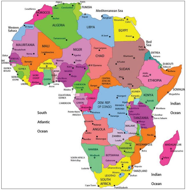
The United Nations geoscheme divides the continent into five major regions.
Northern Africa, which includes Algeria, Egypt, Libya, Morocco, Sudan, Tunisia, and Western Sahara.
Eastern Africa, which includes British Indian Ocean Territory, Burundi, Comoros, Djibouti, Eritrea, Ethiopia, French Southern Territories, Kenya, Madagascar, Malawi, Mauritius, Mayotte, Mozambique, Réunion, Rwanda, Seychelles, Somalia, South Sudan, Uganda, United Republic of Tanzania, Zambia and Zimbabwe.
Middle Africa, which includes Angola, Cameroon, Central African Republic, Chad, Congo (Congo-Brazzaville), the Democratic Republic of the Congo (Congo-Kinshasa), Equatorial Guinea, Gabon and Sao Tome and Principe.
Southern Africa, which includes Botswana, Eswatini (Swaziland), Lesotho, Namibia and South Africa
des Benin, Burkina Faso, Cabo Verde (Cape Verde), Côte d’Ivoire (Ivory Coast), Gambia, Ghana, Guinea, Guinea-Bissau, Liberia, Mali, Mauritania, Niger, Nigeria, Saint Helena, Senegal, Sierra Leone and Togo.
History
The history of Africa is long, complex, and has often been under-appreciated by the global historical community. Africa, particularly Eastern Africa, is widely accepted as the place of origin of humans and the Hominidae clade (great apes). The earliest hominids and their ancestors have been dated to around 7 million years ago, including Sahelanthropus tchadensis, Australopithecus africanus, A. afarensis, Homo erectus, H. habilis and H. ergaster -the earliest Homo sapiens (modern human) remains, found in Ethiopia, South Africa and Morocco, date to circa 200,000, 259,000, and 300,000 years ago respectively, and Homo sapiens is believed to have originated in Africa around 350,000–260,000 years ago.
People of Africa
Africa is now widely recognized as the birthplace of the Hominidae, the taxonomic family to which modern humans belong. Archaeological evidence indicates that the continent has been inhabited by humans and their forebears for some 4,000,000 years or more. Anatomically modern humans are believed to have appeared as early as 200,000 years ago in the eastern region of sub-Saharan Africa. Somewhat later those early humans spread into northern Africa and the Middle East and, ultimately, to the rest of the world. Whereas the majority of Africa’s peoples are indigenous, European colonial settlers constitute the largest majority of new peoples, with substantial numbers in Kenya, South Africa, Zimbabwe, Zambia, Namibia, and Mozambique. Dutch settlers first arrived in South Africa in 1652; their descendants now constitute the main Afrikaner, or Boer, population.
The vast majority of European settlers arrived after the 1885 Berlin West Africa Conference and the resulting “scramble for Africa,” during which European leaders carved out spheres of influence. Attendant, but unassociated, with the scramble, French and Italian settlers also established new communities in North Africa and, to some extent, western Africa. The colonial-era began to disintegrate in the 1950s.
The major drainage basins The major drainage basins in Africa are those of the Nile, the Niger, the Congo, the Zambezi, and the Orange rivers and of Lake Chad.
Nile basin
The Nile, which is about 4,132 miles long, is the longest river in the world. From Lake Victoria, it flows, as the Victoria Nile, into Lake Albert, from which it emerges as the Albert Nile. Farther north it is known as the Al-Jabal River. Thereafter, having received several tributaries, it becomes the White Nile and finally the Nile, emptying at last into the Mediterranean Sea.
Niger basin
The Niger basin is the largest river basin of western Africa. The Niger River, which rises in the mountains of Guinea and enters the sea through its delta in southern Nigeria, is about 2,600 miles in length. Rapids interrupt its course at several points, although some of these (such as below Bamako, Mali) have been submerged in waters impounded by dams.
Congo basin
With a total area of about 1,335,000 square miles, the Congo basin consists of a vast shallow depression that rises by a series of giant steps to an almost circular rim of highlands through which the river has cut a narrow exit into the Atlantic Ocean. The Congo River is some 2,900 miles in length. Its many waterfalls and rapids cause its valley, like that of the Nile, to lose elevation quickly. The Congo enters the sea through a swampy estuary that is about 6 miles wide at its mouth.
Zambezi basin
The Zambezi River is about 2,200 miles in length and occupies a basin with an approximate area of 463,000 square miles. Originally, there were two rivers, corresponding to the upper and lower courses of the present river; the valley of the lower section eroded toward the headwaters until it captured the waters of the upper section. At the mouth of the main river is a delta about 37 miles wide.
Orange basin
The Orange River is the longest in South Africa. Flowing across almost the entire width of the country, it makes its way from the highlands in the east through the Kalahari depression in the west to empty into the South Atlantic Ocean. Its major tributary, the Vaal River, is one of its northern headwaters; the two rivers together have a combined length of about 1,300 miles. Together with other major rivers on the continent, the Orange–Vaal river system shares the characteristic of flowing over steep gradients for numerous stretches of its course. The largest drop (about 400 feet) occurs at the Augrabies Falls.
Chad basin
The Chad basin constitutes the largest inland drainage area in Africa. Lake Chad, a large sheet of freshwater with a mean depth between 3.5 and 4 feet, lies at the centre of the basin but not in its lowest part. Lake Chad is fed by three major streams, the Komadugu Yobe, Logone, and Chari, but these are in danger of having their waters captured by the drainage systems of rivers that flow in opposite directions. Lake Chad itself, with an area of only some 5,000 square miles, was formerly much more extensive.
Geologic history
The African continent essentially consists of five ancient Precambrian cratons Kaapvaal, Zimbabwe, Tanzania, Congo and West African-that were formed between about 3.6 and 2 billion years ago and that basically have been tectonically stable since that time; those cratons are bounded by younger fold belts formed between 2 billion and 300 million years ago. All of those rocks have been extensively folded and metamorphosed. Precambrian rock outcrops appear on some 57 per cent of the continent’s surface, while the rest of the surface consists of largely undeformed younger sediments and volcanic rocks.
The oldest rocks are of Archean age (i.e., about 4.6 to 2.5 billion years old) and are found in the so-called granite-gneiss-greenstone terrains of the Kaapvaal, Zimbabwe, and Congo cratons. They consist of grey, banded gneisses, various granitoid, and rather well-preserved volcanic rocks that show evidence of submarine extrusion and formation under high temperatures. The rock type komatiite is particularly diagnostic of those volcanic sequences and is almost exclusively restricted to the Archean Eon. The cratons were tectonically stabilized by voluminous granite intrusions toward the end of the Archean and were then covered by clastic sediments, some of which contain economically important gold and uranium deposits.
Natural Resources
With huge forests, many rivers and a variety of minerals, Africa is highly rich in natural resources. Different resources are found in different parts of Africa. Rich in minerals, Africa is the world’s largest producer of diamond, gold and platinum around 95% of the world’s diamond is found in Africa. Zaire in Africa is the largest producer. African countries like South Africa, Zimbabwe and the Democratic Republic of Congo produce around 50% of the world’s gold. Petroleum is found in Nigeria, Libya and Angola. A large reserve of other minerals found in Africa is cobalt, copper, chromium, uranium, platinum and bauxite. Despite so minerals found in Africa, there are not many industries developed. This is due to the lack of iron ore and coal, which are the basis of industrial growth. Apart from mineral resources, Africa is rich in timber, fruits, vegetables, rubber, palm trees, dates, cacao, banana, papaya, jackfruit, orange, grapes, cashew nut, yam, cassava, maize, wheat, rice, groundnut, coffee and cotton (Iken Edu).
References:
1. India Today Web Desk, 2018
2. National Geographic
3. Kwamina Busumafi Dickson, 2021. Africa. Britannica
4. Ikon Edu.


