By THAN HTUN (GEOSCIENCE MYANMAR)
EPISODE:43
Duncan John Sloss and Sir Laurance Dudley Stamp
Rangoon College was established in 1878 as an affiliated college of the University of Calcutta and was managed by the Education Syndicate set up by the British colonial administration. The college was renamed Government College in 1904 and University College in 1920. Rangoon University was founded in 1920 when the University of Rangoon Act merged University College and Judson College. Rangoon University became one of the most prestigious universities in Southeast Asia and one of the top universities in Asia, attracting students from across the region. Duncan John Sloss was the first principal, and Laurance Dudley Stamp was the first professor of Geology and Geography at Rangoon University College. I would like to present Professor Stamp’s contributions to Myanmar geology during his tenure in Burma.
Duncan John Sloss
Before introducing Prof L D Stamp, it is important to mention Principal Duncan John Sloss, as both were assigned to work at Rangoon University. D J Sloss, a British scholar, was born in the Toxteth Park area of Liverpool on 19 June 1881. Sloss attended Oulton School, a secondary school for aspiring teachers, and studied at Liverpool University under the distinguished scholar Oliver Elton, where he earned an MA. Sloss had considerable experience teaching in English schools. In 1907, he became a founding member of a Rugby Football Club known as The Aliens, which at the time restricted membership to schoolteachers. He returned to his alma mater in 1911 as a 29-year-old university tutor at the University of Liverpool.
Sloss spent his early professional years in British colonial India, joining the Indian Education Service in 1920. He helped establish and organize University College, Rangoon, serving as its Principal from 1923 to 1937. Under his leadership, the University grew from fewer than 500 students to well over 2,000 by the 1930s. However, Sloss faced challenges, including the 1936 student strike led by Ko Nu and editor Aung San, which spread across the country and lasted until 11 May 1936. Afterwards, he moved to Hong Kong and became vice-chancellor of the University of Hong Kong, a position he held from 1937 to 1949. Sloss passed away in Oxford on 29 July 1964.
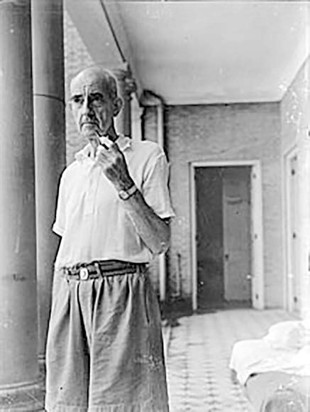
Sir (Laurance) Dudley Stamp
Sir Laurance Dudley Stamp (9 March 1898 – 8 August 1966) was the first professor of geology and geography at Rangoon University and the London School of Economics and one of the most internationally renowned British geographers of the 20th century. Stamp was born in Catford, London, in 1898, the seventh child of a shopkeeper. He attended University School, Rochester (1910-13), where he joined the Rochester and District Natural History Society. He then studied for a BSc at King’s College London, graduating with first-class honours in 1917. Following military service, he returned to King’s as a demonstrator. Stamp sat for the BA in 1921 and again achieved first-class honours. He was awarded a DSc in the same year. Stamp spent the early 1920s as a petroleum geologist in what was then British Burma and became a professor of geology and geography. In 1923, Professor L D Stamp was appointed by the University of Rangoon to organize the new Department of Geology and Geography. The Stamp papers, held at the Department of Geography, University of Sussex, contain extensive information on his organization of the Land Use Survey, as well as personal and professional papers illustrating his life and career.
During his tenure as a professor of geology and geography at the University of Rangoon, Stamp contributed the following reports to the geology of Myanmar: -
The Irrawaddy River (1940), Some evidence tending to prove a Mesozoic Age for the Granites of Tenasserim (1926), An Outline of the Tertiary Geology of Burma (1922), Geology of Part of the Pondaung Range, Burma (1922), Seasonal Rhythm in the Tertiary sediments of Burma (1925), Note on some Fossiliferous Localities in the Peguan Rocks of Central Burma (1927), The Igneous Complex of Green Island and the Amherst Coast, Lower Burma (1926), and Some Remarks on the Tectonics of Burma (1922). Then Stamp wrote several books such as The Vegetation of Burma (1925), A New Geography of India, Burma and Ceylon (1948), Asia, and Regional and Economic Geography (1929). Of all his informative reports, due to limited space, the significant points of ‘An Outline of the Tertiary Geology of Burma’ could be extracted as follows: -
An Outline of the Tertiary Geology of Burma
Introduction
For more than a quarter of a century, the Tertiary geology of Burma has been the subject of investigation from the point of view of the country’s petroleum resources. A vast amount of detailed information must be stored in the private files of the various oil companies operating in Burma, and it is a source of continual regret to the geologist that at least some of this information – much of which has great scientific but little commercial value – cannot be made public. Although there exists Dr Noetling’s important but misleading monograph on the supposed “Miocene Fauna of Burma”, published in the Palaeontographia Indica, 1901, it is only within the last decade that the Tertiary stratigraphy has been seriously considered from a palaeontological standpoint, and for this progress, the officers of the Geological Survey of India are almost entirely responsible. In this direction, immensely valuable results have already been obtained, though the study is scarcely more than in its infancy.
The object of the present paper is to bring together in the form of a summary the results of previously published investigations, to fill in at least a few of the gaps by including the results of the writer’s observations in certain extensive areas in the Chindwin Districts and elsewhere in Burma, but more especially to apply certain important principles which have deduced as a result of the study of the Tertiary deposits of North-Western Europe.
Physical Geography of Burma
Burma falls very simply into well-marked natural regions, the physiography of which is controlled mainly by the geology, whilst minor subdivisions can be made on a climatological basis. The main divisions are as follows: -
The Shan Plateau
It occupied the whole of the east of the country. It is a region of highly folded Pre-Palaeozoic, Palaeozoic, and early Mesozoic rocks, the folds running mainly north and south. Bounding this region on the west is a great line of dislocation, which has a rough north and south direction for hundreds of miles. This may be termed the Shan Boundary Fault, and the change from the central lowlands to the plateau is at once abrupt and sharply defined. Immediately to the east of the fault, there is usually a strip of crystalline rocks. The Shan Plateau is, on average, between 3,000 and 4,000 feet above sea level and is continuous with the plateau of Yun-nan. As a contrast to the fine highland scenery of the Palaeozoic rocks, well known to the frequenters of Burma’s favourite hill-stations-Maymyo and Kalaw- there are broad, level tracts marking the sites of lake basins are of some importance as yielding brown coal (as in the coalfields of Lashio, Namma, etc.), and in one case oil-shale. Some of the basins are still occupied by lakes (such as Lake Inlay’). It may be noted, en passant, that the coals of the Shan States belong to two distinct groups: firstly, the Late Tertiary or Pleistocene lignites occurring almost horizontal beds in the basin already mentioned; secondly, the humic coal of early Jurassic age occurring in strata which have been subjected to the same intense folding as the Palaeozoic sediments. The coals of Kalaw (Loi-an) belong to the latter group.
The important points to notice are: -
(a)the main folding is post-early Jurassic and pre-late Tertiary,
(b) the absence of early Tertiary deposits, which are of such enormous thickness in the central Tertiary region, makes it almost certain that the main folding and the initiation of the Shan Boundary Fault are pre-Tertiary,
(c) from the slightly tilted late Tertiary deposits in the lake basins of the Shan Plateau must have played the part of a “stable block” during the late Pliocene folding of the main Tertiary region of Burma.
The Central Tertiary Belt
A strip of country 500 or 600 miles from north to south and averaging 130 miles wide, bounded by Shan Plateau on the east and by the great fold-range of the Arakan Yoma on the west. Whilst the boundary is sharply defined on the east, on the west, the Tertiary region rises somewhat gradually from the Irrawaddy Valley to the foot-hills of the Arakan. It is by no means a monotonous tract. Its southern half is occupied by the valleys of the Irrawaddy and Sitting rivers on the west and east, respectively, separated by the low but somewhat inaccessible range of the Pegu Yoma. In the south, one may distinguish it as a separate region, the great flat delta of the Irrawaddy, which drops very gradually to the shallow waters of the Gulf of Martaban. The northern half of the Tertiary region is occupied by the valleys of the Chindwin and the Irrawaddy on the west and east, respectively. Climatologically, the Tertiary belt, being on the lee of the Arakan Yoma and protected from the rain-bearing South-West Monsoon, enjoys a dry and healthy climate. The rainfall is about 20 inches in the latitude of Yenangyaung, giving rise to a tract of semi-desert. The rainfall increases to the north and the south, as well as to the west as one approaches the Arakan Yoma, and the semi-desert with its thorny shrubs, Euphorbias, Cacti, and stiff-looking Toddy Palms passes gradually into shrubland and then into Monsoon Forest of teak-trees. Elevation and soil play an important part in the ecology of the country.
The Fold Range of the Arakan Yoma
The Fold Range of the Arakan Yoma forms an important barrier bounding the Tertiary region on the west. It stretches from the Naga Hills of Assam in the north to the extreme southwestern point of Burma in Cape Negrais, being continued by the rugged islands of the Andaman and Nicobar groups into Sumatra (Barisan Range) and Java. Topographically, the range is still largely unknown, with large areas being unmapped in detail, whilst geological knowledge depends on a few incomplete traverses. Throughout the length of the range, there is no line of transverse communication- not even a well-known forest track and large areas are uninhabited. As knowledge of their geology slowly accumulates, it becomes more and more certain that the structure of the Arakan Yoma is that of a complex anticlinorium. The core consists of pre-Tertiary rocks (including at least Triassic and Cretaceous-Cenomanian and possibly Danian). The core is flanked on either side by Tertiary rocks. The core is flanked on either side by Tertiary rocks. Certain facts of considerable importance disengage themselves from the scattered scraps of available information: -
(a) at or near the base of the Tertiary deposits on the eastern side, there is a very thick basal conglomerate (Paunggyi Conglomerate) which is lower Eocene in age.
(b) even though the Eocene deposits take part in the folding and have been ridge into steep-limbed anticlines or overfolds, there is always a marked change from the comparatively unaltered Tertiary to the cleaved and puckered Cretaceous and earlier rocks.
(c) there is a notable difference between the Tertiary deposits on two sides of the Arakan Yoma.
One is forced to conclude that the great fold of the Arakan Yoma was initiated in late Cretaceous times and, even as early as the Eocene, constituted a barrier between the areas of deposition on the east and west, respectively. In several cases where the junction between the Tertiary and pre-Tertiary rocks on the eastern side of the Arakan Yoma has been examined, it has been found that it is faulted. A great line of dislocation may exist between the two- between the Arakan Yoma and its foot - and if this were the case, the Tertiary region of Burma would, in reality, be a typical rift valley.
Bordering the Arakan Yoma
Bordering the Arakan Yoma on the west is a strip of wild, rugged country, deeply intersected by bays and gulfs and fringed by islands forming the Arakan coast. It consists of Tertiary rocks, which belong to the Assam Gulf deposition as distinct from the Burma or Pegu Gulf on the other side of the Arakan Yoma. (To be continued).
References:
1. Stamp, L Dudley. 1922: An Outline of the Tertiary Geology of Burma, the Geological Magazine, Vol LIX.
2. en.Wikipedia.org


