In 2020, the government constructed a 56-mile transport passage between the ice-covered town of PutaO and Khaunglanphu, which is located in the northeast of Myanmar, to facilitate the education, health and economic aspects of the local people. The development of the tourism sector will improve the socio-economic life of the local people by allowing domestic and foreign tourists to visit the mountain area, which is covered with snow all the time.
Among the ASEAN countries, mountain climbers frequently visit the Phonkanrazi and Khakaborazi ice-capped mountains located in PutaO, which is characterized by its snowy landscapes.
A road has been constructed from PutaO to Hsanhlutchet Hill of Khaunglanphu, spanning a distance of 76 miles. The remaining 56 miles of road have been completed by the Ministry of Border Affairs, enabling travellers to journey freely day and night.
“The mountain road that once posed various difficulties for travellers from Khaunglanphu, Nagmon to PutaO is now accessible. Bridges have also been constructed. Landslides occur during the rainy seasons and in severe weather conditions.
“However, after recent repairs following a landslide that blocked the road a few days ago, goods began flowing to PutaO on 17 April. Since there is no border gate, PutaO remains the primary destination for commodity flows. Some goods are redistributed to other regions and states after being transported from PutaO.
“Due to the lack of flat lands or plains, it is challenging to engage in other agricultural activities. Many locals on the hills and mountains survive themselves from growing spices. With the development of the tourism sector, employment opportunities for locals will increase.
Opening up the tourism sector in the Khaunglanphu region, which is abundant in natural beauty, will raise awareness of Myanmar’s tourism potential worldwide,” U Than Tun, Deputy Director of PutaO District Administration Body, explained.
Khaunglanphu Township, situated at an altitude of 4,680 feet, is a hilly town. Locally grown produce such as rice, corn, and spices, including small fruits found in the roots of plants like ginger, are often sold at the PutaO local market and exported to China. The PutaO region is primarily known for grapefruit cultivation, along with the production of medicinal plants, tubers, iced fish, and vegetables.
Renowned as a destination for snow-capped mountain travel areas, if Khaunglanphu flourishes as a tourist region, it will significantly e n h a n c e M y a n mar’s tourism sector by attracting both local and foreign visitors.
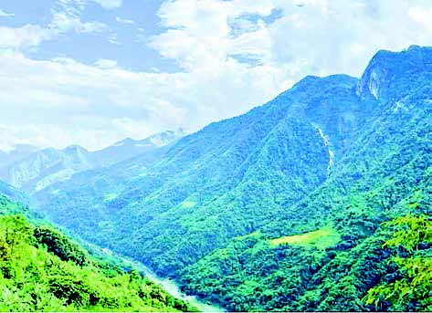
Khaunglanphu experiences cold weather and snow throughout the year. At the foot of the hill in Khaunglanphu, where the Maykha River and Archankha River converge, locals refer to it as the confluence. From November to March, temperatures annually drop below freezing, while foggy conditions characterize the remaining months.
Mount Shengkhong, Mount Zeitung, Mount Gitok, and Mount Urein, all towering above 9,000 and 10,000 feet, are often cloaked in ice.
The People’s Republic of China borders the town to the east and north, Nagmon and Machanbaw to the west, and Sumprabum and Sawlaw to the south. Established in the colonial era, Khaunglanphu boasts a rich historical background and natural beauty.
It is also crucial for national border security, and nature-based tourism flourishes in the Khaunglanphu region, which is constantly surrounded by clouds, lakes, and mist. — Nyein Thu(MNA)/TKO


