By THAN HTUN (GEOSCIENCE MYANMAR)
EPISODE:56
Barren Island
According to HL Chhibber (1934), the volcanoes of Barren Island and Narcondam are located along the southern extension of the igneous activities of the central line. Therefore, excluding the only active volcano in the Andaman Sea would provide an incomplete overview of the igneous activities in Burma. These volcanoes are part of the Indian Union Territory of Andaman and Nicobar Islands and are located approximately 86 miles northeast of Port Blair.
FR Mallet, former Superintendent of the Geological Survey of India, wrote some early references to Barren Island in the Records of the Geological Survey of India from 1895. The key points are summarized as follows: -
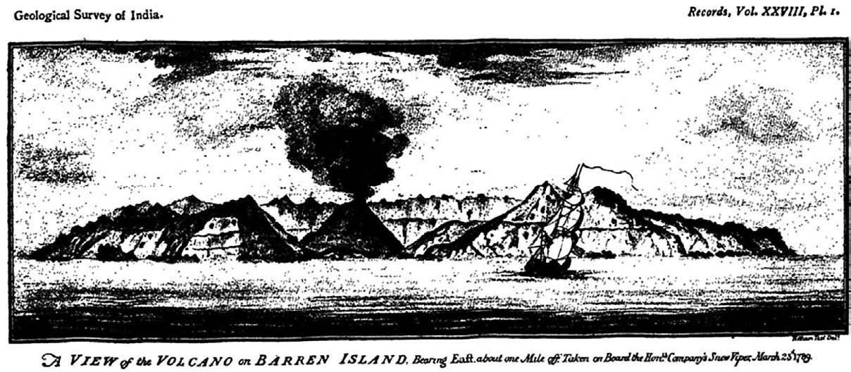
When writing the description of Barren Island that appeared in the twenty-first volume of the Survey Memoirs, I was unable to refer to any accounts of the Volcano earlier than that by Lieutenant Colebrooke, who saw it from a distance in 1787 and that by Captain Blair, who landed during a violent eruption in 1789. The name ‘Barren Island, ‘however, was not originally given by either of those observers: it had been applied before their time to the Volcano, which, by some, had also been called ‘Monday’ and ‘High’ Island. It was clear, therefore, that the island was more or less known before Blair’s visit, and it seemed possible that someone or more accounts of it, by navigators who had seen or even landed on it, might be in existence, and that perchance some allusions to its volcanic condition earlier than those mentioned above, might be on record.
Van Linschoten, 1595.: The earliest indication of the island being known, that I am aware of, is to be found in the original Dutch edition of Van Linschoten’s voyages. This work contains two maps engraved in 1595, one of India and some adjoining countries, the other of the Malay Peninsula and archipelago. The ‘Andemaon’ and adjacent islands are included in both, the configuration in one being identical to that in the other. ‘Nacondaon’ is placed in lat. 14° 20’. No longitudes are given, but the position is 90 miles E or E ½ N, from the northern end of the Andamans. About 45 miles S by E from “Nacondaon” (Narcondam), in Lat 13° 35’, there is a nameless island which is much nearer the true latitude of Narcondam (13° 26’) than that to which the name is attached. It is probably duplicating that island through a discrepant and more accurate determination of its position.
A second small and nameless island is marked about 45 miles east of the Andamans, in Lat. 12° 25’. This is some 10- or 12-miles N W from the true position of Barren Island, for which, I think, there can be no reasonable doubt that it is meant, as there is no other land for which it can be intended.
Linschoten makes no mention of having himself visited the Andaman Islands. In the titles of the above-named maps, it is stated that they were “perfectly drawn and examined with the most expert cards of the Portingales Pilot,” which suggests that the island just mentioned was inserted by Portuguese authority. As the explorer who charted them through Narcondam worthy of a name on the map, perhaps if Barren Island had been in eruption, and thus especially attracted his attention, he would have attached one to it also.
Gough, 1708.: On many charts of much later date than Linschoten’s, no land near the position of Barren Island is indicated. Hence, it was a discovery to Captain H. Gough, when he sighted it in 1708. The log of his ship, the Streatham, is preserved at the India Office. On the 17th December of the year just mentioned, the following entry was made: - “Now at sunrise, we see Land from W b N to N W b N, at seven o’clock ye squall being over we had an Island appearing thus” (small sketch given); then ye another land bore from W to N W by W distance, I judge, 10 to 12 leagues. Now, we have no drafts that anything answers these bearings; therefore, I commenced one. From ye Lat 11°, which will include ye shoal, to Lat. 14°, which will carry me to ye Cocos Islands; see the other side.” The last sentence refers to Gough’s M S chart, on which the island, without any name, is marked in Lat 11°53’, and 58 miles E S E from the Andaman coast. It is about 23 miles south of the true position of Barren Island, an error which is probably because while Gough obtained his latitude on the 16th by observation, that on the 17th was by “account”. There is, however, a discrepancy between the log and the chart. In the former, his latitude on the 17th is given as 12° 30’, while on the chart, his position at noon is marked in Lat. 12° 18’. If this difference were applied to the island, it would bring its latitude within 11 minutes of the correct one.
The island, when seen, was at a distance of 8 or 10 leagues from the E S E, and measures on the chart about four miles by two, with the length perpendicular to the line of sight; but his was a mere eye-estimate.
There is a rough free-hand sketch of the island in the log from the point of view just mentioned, which represents it as a very high one, with the culmination near the S S W extremity, a nearly flat top inclining gently towards the N N E, and steep slopes at the ends; exactly the appearance which Barren Island, at present, would have if viewed from the same position, except that the height, in proportion to the breadth, in the sketch, is a good deal more than in nature. This is so obviously due to exaggeration, which is likely expected in a rough outline dashed off currente calamo, that it would be a waste of space to raise the question of whether the volcano was much higher in 1708. Had such been the case, indeed, the truncation of the ancient cone must necessarily have been far less than is implied by the sketch, and the latter would entirely fail to represent the facts. There is no indication in the sketch, of smoke rising from the volcano.
Various Observers.: Reference to the observations of several navigators may be found in a “Memoir of a chart of the Indian Ocean”, 1787 (contained in the first volume of Darlymple’s Nautical Memoirs), where on page 36 we read: -
“The island, called Barren Island by Captain Taylor and Captain Justice, Monday Island by Chenye, from Old Draughts; and Alto by Captain Baker and C Alves are in
Lat 12° 20’ N by C Mills, 1758.
12° 23’ Alves, 1760.
12° 20’ Justice, 1771.
12° 20’ Taylor, 1780.
Long. by Captain Taylor’s Observations of the Sun and Moon 93° 10’E from Greenwich.
Cheyne, 1748.: The log of Capt. Cheyne’s ship (the Lapwing) shows that Cheyne passed “Monday” (Barren) Island at the close of October 1748 and saw it from various points of the compass, but he made no nearer approach than eight or nine leagues. His observed latitudes on the 28th and 29th, combined with the bearings and estimated distances of the island, respectively made it in lat. 12° 6’and 12° 16’. He remarks “This by some is called Monday Island, but we have no account of it in the draught.”
Mills, 1758.: The year 1758, Captain Mills, of the Drake, noticed “Land even with water” in Lat 11° 12’, and “he says the land and (Alto, which he calls) Arracondam, bears of each other N b E ½ E and S b W ½ W distant 21 leagues”, which marks the latitude of Alto (Barren Island) 12° 12’, or within 4 minutes of the now accepted value. This quotation is of interest from the name Arracondam (presumably a corruption of Narcondam) being applied to Barren Island. However, I do not think Captain Mill’s application of the name can prove anything, as he probably used it through imperfect information. Still, the point is worthy of notice in connection with the origin of the term, Narcondam, alluded to in my memoir on the volcanoes.
Justice, 1771.: I have not met with any record by Captain Alves or Baker. The discovery of a dangerous rock was reported by Captain Justice in 1771, which he describes in some detail and at the conclusion says “Imagining I was to the westwards of the Little Andaman I stood to the N N E-wards to get its true place, but on 2 November, at 6 am, I was surprised to see Barren Island; it lays by my account, not allowing the current, to be 20 miles to the westwards of Barren Island in the latitude of 11°07 or 11°12.”
Taylor, 1780.: The following remarks by Captain Taylor of the Ship ‘Ceres’ are perhaps worth reproduction in full as illustrative of the inaccuracy and uncertainty that prevailed about Barren Island until late in the last century: -
“12 January 1780, “per medium of 13 good sights of the longitude found ourselves in 93° 36’longitude from Greenwich, which is 1° 33’W since the last sights and by the charts nearly the longitude of the Islands, laid down in 12° and 11° 30’N Lat by the name of Barren Island. Kept a very good lookout in the night and sounded as per log; next morning at daylight saw a pretty large Island bearing N E ½ E, 10 leagues, the ext of the Andamans (just in sight) from W N W to S W by S, 9 or 10 leagues. Till noon, we had a good observation but could not determine whether the island in sight was the northernmost Barren Island or Narcondam; we observed in 11° 59’N, the lat of the northernmost Barren Island as laid down in the charts; the Island bearing N E by N between 8 and 9 leagues distant which makes it come nearest the lat of Barren Island. A day or two afterwards, by a good observation within two or three miles from the northern end of it, find its latitude to be 12° 20’northern (21 miles to the northwards of its situation upon the Charts) and its longitude, by several very good observations of the Sun and Moon, to be 93° 10’ E from Greenwich, etc.
“I likewise have it from good authority that Captain Sharrington of the Bahar country ship saw the rocks under its ship bottom and sounded in 4 fathoms Barren Island being N N W 5 or 6 leagues. In the charts there is some dangers laid down to the southwards of the southernmost Barren Island; I imagine it is meant to be placed to the southwards and the northernmost, as I think it seems doubtful whether there are but one or two Islands. The Island of Narcondam bears N by E ½ E from Greenwich, both ascertained from very good observations. The Island Narcondam and Barren Island appear very different when seen at some distance; so that, independent of their latitudes, with a simple sketch of each Island a man could be at no loss readily to know the one Island from the other. Narrcondam makes like a sugar loaf, quite flat at the top, and may be seen at least 18 leagues from the masthead, for we saw it 13 or 14 leagues from the poop pretty high out of the water, the weather rather hazy; this distance may be depended upon as it’s calculated from the bearings and differences of latitude.
One Island or two? In explanation of Captain Taylor’s surmise, whether one Barren Island or two existed, I may say that in various atlases of the eighteenth century, two small islands are marked, one nearly due north of the other, on a meridian some 50 miles east of (what appears to represent) the South Andaman. The altitude of one varies from 11° 21’to 11° 30’; that of the other from 11° 59’to 12°8’. In the French Atlases, these are called the ‘Iles Rases,’ while in some English, they are called the ‘Barren Islands, and in others, the ‘Flat Island.’ However, one or two of these names came into use (possibly through some mistranslation from one language to another), the northern Isle Rase, as charted, agrees very fairly in position with Barren Island and cannot be intended for anything else. What the southern Isle Rase was intended for, I do not know. It was not meant for the rock east of Duncan’s passage, for in some Atlases (e.g., Le Neptune Oriental), the latter is marked in addition to the Isles Rases, in latitude 10° 55’or 11° 0’.
Perhaps the most likely solution is that (like Narcondam, as previously mentioned) Barren Island was duplicated on the charts through discrepant determinations of its position. But it is at least a possibility that, like Graham’s Island, in the Mediterranean, the southern Isle may have been an ephemeral one due to a volcanic eruption, chiefly of fragmentary ejecta. It is conceivable that, after it had been washed away by the sea, the last visible remnants were the rocks reported by Captain Sharrington, five or six leagues S S E of Barren Island, and that even these subsequently disappeared, thus explaining Horsburgh’s remark that Sharrington’s account “is rendered doubtful, for no signs of shoal-bank in the situation described have been discovered for many years.”
Another possibility is that the temporary Island, and Sharrington’s rocks, were S S W of Barren Island (the S S E bearing given by Taylor being due to a not uncommon kind of clerical error). This would place them in the line joining Flat Rock, Barren Island, and Narcondam, and on the suppositional submarine ridge of Dr Prain, and would account, in another way to the suggested above, for the rocks not being re-discovered to the S S E, as well as for the statement of the Portuguese Caption. It would be useless to pursue this speculation reared on such a slender basis.
References: Mallet, FR, 1895: Some early allusions to Barren Island; with a few remarks, the Record of Geological Survey of India, Vol XXVIII, Calcutta, India.


