By THAN HTUN
(GEOSCIENCE MYANMAR)
EPISODE:58
Volcanoes of Narcondam and Barren Island
This article continues from Episode 57, highlighting key points from HL Chhibber’s 1934 account of Volcanoes of Narcondam and Barren Island.
The farther south, though outside Burma, is situated on the same line, with the volcanic islands of Narcondam and Barren Island, which deserve special mention for several reasons. Firstly, their rocks bear a very close similarity to those of Burma, and in reality, the volcanoes themselves form a southern continuation of those of Burma. Secondly, they are the only volcanic islands in the Bay of Bengal, while Barren Island, perhaps, constitutes the only instance of an active volcano in these seas. Both of them rise abruptly out of comparatively deep water and may furnish material for the modern petrologist who desires to study the nature of magmas that have not been affected by surface contamination and assimilation. It is regrettable that being situated in rather out-of-the-way places, they have not yet received the full treatment they deserve.
Narcondam.
Topography: Narcondam lies about 75 miles NNE of Barren Island. Like the latter, it rises abruptly out of deep water, with depths of about 450, 565, and 562 fathoms being noted on the chart within about one kilometre from the island in various directions. Its area is 2.78 square miles, and it has an oval outline. Its greatest length, northeast-southwest, is about 2.5 miles, and its greatest width is about 1.75 miles. It has a roughly conical form, with sides deeply scored by ravines. The summit, 2,330 feet above the sea, is rather to the south of the centre of the island, and it bears no crater. The culminating portion of the volcano includes three hummocks, of which the northern is the highest. The shore is cut away by wave action into cliffs, up to several hundreds of feet high.
The lavas that build Narcondam, according to HS Washington, are very uniform in composition. Mallet described them as hornblende-andesite, but Washington, under modern terminology, designated them dacite, as his analyses showed that the silica content is much too high for andesite, although little or no quartz is visible.
Hornblende-Andesites: The specimens of lava collected from the highest point of the mountain and different localities on the slopes and around the coast are all compact or very slightly vesicular rocks, in which crystal of white translucent felspar and black or dark-brown hornblende, with occasional biotite crystals, are disseminated through a groundmass, which is generally light-grey in unweathered specimens. According to H S Washington, the felspar phenocrysts comprise orthoclase, andesine, and calcic-plagioclase, about labradorite Ab1 An2. The first two minerals are mainly untwined and show central clusters of minute inclusions. The crystals of dark yellowish-brown hornblende are about as large as those of the feldspar but are far less numerous. An occasional dark-brown biotite is seen, and large sections of hornblende and biotite show very dark margins. Magnetite and apatite also occur. The groundmass is microcrystalline and mainly felspathic, being composed of andesine with specks of augite, hornblende, magnetite, and biotite.
Agglomerates: Volcanic agglomerates composed of rounded and angular fragments of lava of every size up to three or four feet in diameter, embedded in a finer matrix, are exposed in sections along several parts of the coast. As stated, Washington, and Mallet believed, because of the “acid” and very uniform character of the rocks and the absence of a crater and ash, that the island was a normal eruption.
Barren Island.
Barren Island lies approximately 12° 15’N Lat and 93° 50’E Long, and is about 100 kilometres east of the southern end of Middle Andaman Island. Oldham states, “Soundings show that the cone rises from 800 fathoms below the sea.” Barren Island is almost circular, with an area of 3.07 square miles. Most writers on vulcanology have regarded these islands as situated in the continuation of that great zone of volcanic energy, which stretches for some 2,000 miles along the Sunda group of islands, the terrible activity of which was illustrated by the explosive eruption of Karakatoa in 1883.
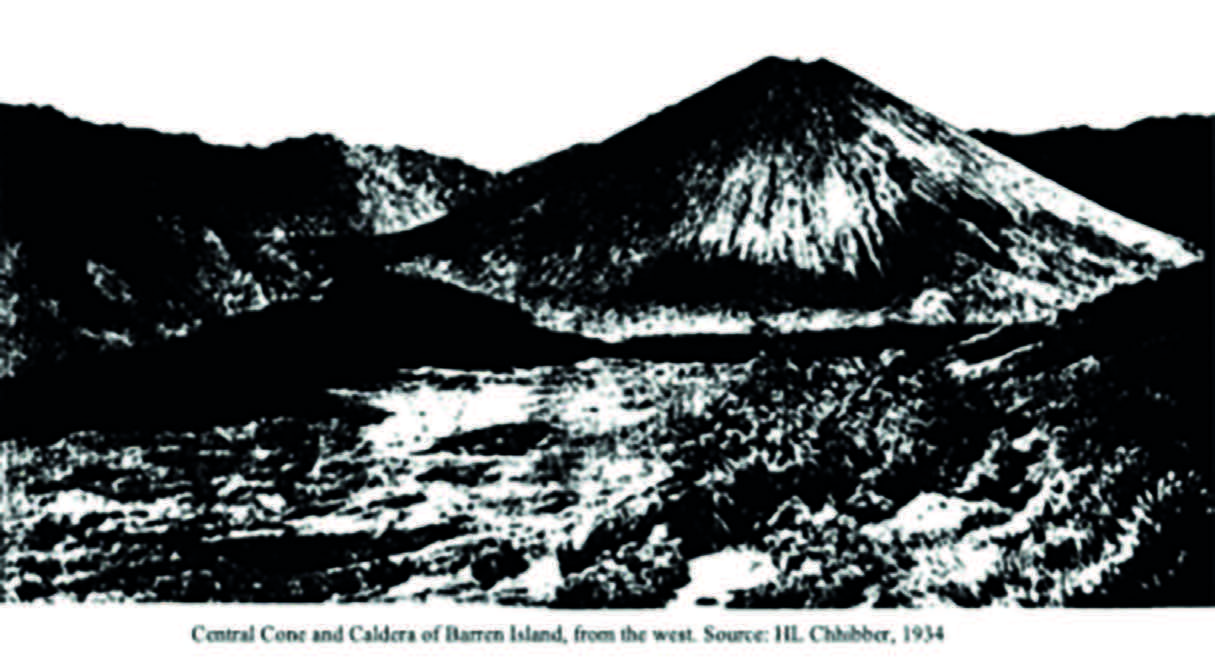
The island consists of an almost circular ridge with heights varying from about 600 feet above sea level on the northwest to 1,160 feet on the southeast. On the western side, there is a deep breach, giving entrance to the interior of the crater. It has a diameter of about a mile, and its floor has altitudes above sea level of about 80 feet near the landing place to 319 feet east of the central cone. Towards the southeast, the slopes, rising to a height of 700 and 900 feet above the floor of the crater, or some 1,100 above the sea, are well wooded. On the north, they are much less steep and high, with rounded outlines towards the top, and are largely covered with loose, black, naked ash.
Central Cone: In the centre of the crater, the central cone rises to a height of about 1,015 feet above the sea, or about 700 to 900 feet from its western foot with, as seen from the west, an almost perfectly symmetrical outline, the sides preserving an even slope of 20°. The truncation at the summit marks the site of the crater, and here, a thin column of stream rises slowly into the air.
The Recent Crater: The recent crater is ovoid, with the major axis lying about S by W-N by E. The highest points of the edge, to the north and south, are 78 feet above the floor. The material inside the crater is loose blocks of lava, scoriae, and ash, but to the southwest of the bottom, there is a mass of solid lava, which is probably in connection with a flow down the side of the cone, which has been covered over by the latest eruption of fragmentary material. The floor has a diameter of 60 feet.
Streams of Lava: Almost encircling the base of the cone are streams of lava, one of which has poured through the breach into the sea. They are all covered with rugged black and scoriaceous crusts and with fissured and hummocky surfaces.
The crater rim is higher on the southeast. Mallet ascribed the fact that the northwestern half of the volcano is of lower elevation than the other half to a bodily sinking of that side.
But it may equally well have been lowered by one of the explosive outbursts, during which the northwestern side was partially blown away. Similarly, the northern side of Mount Popa is of lower elevation than the other sides and also has a breach in that lower wall, and probably the same explanation applies. Moreover, the evidence of the Akyab coast and the Andaman and Nicobar Islands points to a recent uplift of land and not to a subsidence.
Lavas of the Ancient Cone: The ancient cone of Barren Island is largely made up of lava. The specimens described by Mallet are more or less vesicular, with small crystals of white translucent felspar and small granules and crystals of bottle-green, translucent augite disseminated through a dark-grey groundmass. Brownish-yellow olivine is frequently present also. The felspar is triclinic and contains glass enclosures and numerous black opaque particles, many of which have the shape of magnetite crystals. The groundmass is microcrystalline and is made up of minute crystals of plagioclase felspar, with augite and nearly or quite opaque specks, which appear to consist of more or less decomposed augite with some magnetite.
Fragmentary Ejectamenta of the Ancient Cone: Fragmentary ejectamenta interstratified with the lavas of the ancient cone are exposed in some good sections along the coast. In some places, the scoriae are rudely interbedded with irregular layers of lava. One hundred yards northwest of the landing place, a somewhat contorted bed of black volcanic ash is interstratified with a similar alternation of scoriae and lava. They show miniature faults of a few inches throw by which the bed has been dislocated.
Recent Ash on Ancient Cone: A considerable part of the ancient cone, including both the walls of the crater and the exterior slopes, are covered with ash ejected from the central cone. The greater proportion occurring to the north and northeast may be ascribed partly to the influence of the southwest monsoon and partly to the crater rim being lower there. The newer ash differs from most, the older in being nearly or quite black instead of dull red.
Flows of the Central Cone: According to Mallet, there are three distinct flows of quite recent lava, which may be distinguished as the eastern, the southern, and the northern streams. In general appearance, they are all very similar to one another, presenting the same exceedingly rough, hummocky, and fissured surfaces with the black scoriaceous crust broken into pieces of every size up to those many tons in weight. The lava streams have lateral and terminal banks, so they are frequently noticed in the case of Mount Popa and other volcanoes.
The recent lavas, like those of the ancient cone, consist of white, translucent, triclinic felspar crystals and bottle-green translucent augite with frequently a little olivine in a microcrystalline groundmass composed of triclinic felspar, augite, magnetite, apatite, etc. This description compares perfectly with the recent olivine basalts of the Twintaung type from the Lower Chindwin and Mount Popa areas.
Southern Flow: The southern stream broke out a little more than halfway up the cone, at a point now marked by a slight projection. After pouring down the side of the cone, it followed the course of the valley into the sea, which has since then cut the face into a cliff 10 or 15 feet in height. This was the largest flow of all, a considerable part of the area covered by it being obscured by the sand which has been down from the old crater walls to the south.
Northern Flow: The northern stream broke through at about 250 feet below the crater; close to the point of issue, there is a solfatara with an opening eight or nine inches in diameter. From the mouth, steam issued copiously. From the point of issue the molten rock, after reaching the base of the cone, flowed down the valley and over the previous stream from the south, the termination of the later flow being marked by a bank a little to the west of the cone. Mallet believed that the lava had been emitted within a quite recent period, almost certainly within the last century.
Recent Aqueous Deposits: In the lower part of the main gorge, which debouches to the south of the alluvial plain, there is an agglomerate composed of rounded and angular lumps of volcanic rock in the finer matrix which appears to be a deposit of the stream itself. At the mouth of the gorge to the north of the anchorage, another aqueous deposit may be seen, and doubtless, there are many others on the island.
Hot Springs: There are springs of hot water, with a temperature of 116° F. in 1884, which gush forth on the beach at the landing place. The shore between the cliffs of ancient lava and the recent stream has a length of about 40 yards, and along it the hot water issues in numerous places from the shingle. The level of the springs rises and falls with the tide, and when first observed in 1832 the rocks were so hot that the “stones on the shore, and the rocks exposed on the ebbing of the tide, were smoking and hissing and water was bubbling all around them.”
Physical and Geological History of the Volcano: The physical and geological history of the volcano can be divided as follows:
(1) The first and important phase must have formed the volcano, which is now represented by the outer amphitheatre. It is made up of scoriae, ash, agglomerates, and basaltic lava.
(2) The second stage consisted of a great paroxysmal eruption when part of the crater was blown off, and the present breach was formed. Probably, the sea invaded the inner part of the volcano at the same time.
(3) The third stage built up the central pile, which consists of newer fragmentary ejectamenta, ash, scoriae, agglomerate, and lava flows.
(4) Lastly, the flows of recent lava welled out, some of which Mallet believed were not even a century old.
(5) Since the welling out of lava streams, the volcano has been seen in activity by several observers, ejecting red-hot stones, flames, smoke, steam, and Sulphur vapour. The last is responsible for the deposits of Sulphur seen in the solfataras.
References: Chhibber, H L, 1934: The Geology of Burma, Macmillan and Co Limited, St Martin’s Street, London.


