24 February
WITH an impressive 155,800 km² in land area that borders China to the north, Laos to the east, and Thailand to the south, and five administrative divisions of Myanmar in the west, Shan State is the largest of the 14 states and regions of Myanmar.
The expansive state is globally renowned for its beautiful mountainous scenery, ancient pagodas that stand out, prominent historic structures, naturally formed caves, and captivating lakes that attract adventurers and sightseers from far and wide. Travelling around in Shan State is fortunately not at all difficult, with land, sea, and air routes connecting into this mesmerizing land.
A popular choice with tourists is taking the train across Shan State and for that we have the Yangon-Thazi-Shwe Nyaung route and the Mandalay-PyinOoLwin-Lashio route. In this article, we will be highlighting two unique bridges that you will come across on the two popular train routes.
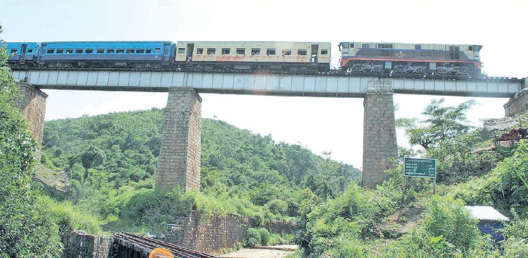
Bawa Than Tha Yar Bridge
First up is the Bawa Than Tha Yar Bridge that links a part of the railroad from Thazi to Shwe Nyaung. The bridge was immortalized in singer Maung Kyi Toe’s song, ‘Kalaw Alun Ta Buda’ and is famous for the breathtaking scenery passengers can view along the bridge’s winding curves.
In the eponymous movie directed by the late director and writer Sayagyi U Thukha around 1959-1960, and starring renowned actor U Zaya and actress Daw May Thit, a lyric from the movie’s song; ‘Bawa Than Tha Yar (Samsara/Cycle of life), moving slowly without rest, until you reach your final stop, people board and people leave, and you continue on your way’; stuck the bridge’s current name over Bridge No. 382 over Nay Nun Creek.
The steel-framed bridge was constructed in 1927 and is 200 feet in length and 62 feet above ground level. It was built to connect Heho and Shwe Nyaung over Nat Nun Creek.
Bawa Than Tha Yar climbs up the hill from Heho along Nat Nun Creek’s bank, crosses the creek and because it could directly intersect with the embankment and the Thazi-Shwe Nyaung highway, it curves back down to the creek and goes under the earlier section of the bridge. This two-tier design was also mentioned in the song to the lyrics, ‘from above to below’, ‘from below to above’, ‘from down low to up high’, and ‘from up high to down low’, with the movie garnering numerous academy awards.
The 86 year old bridge offers an attractive alternate land route to Southern Shan State and an unparalleled view of Shwe Nyaung gorge and Taunggyi mountain range from its tracks.
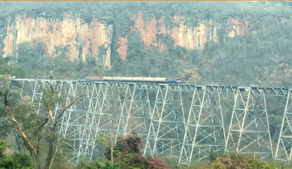
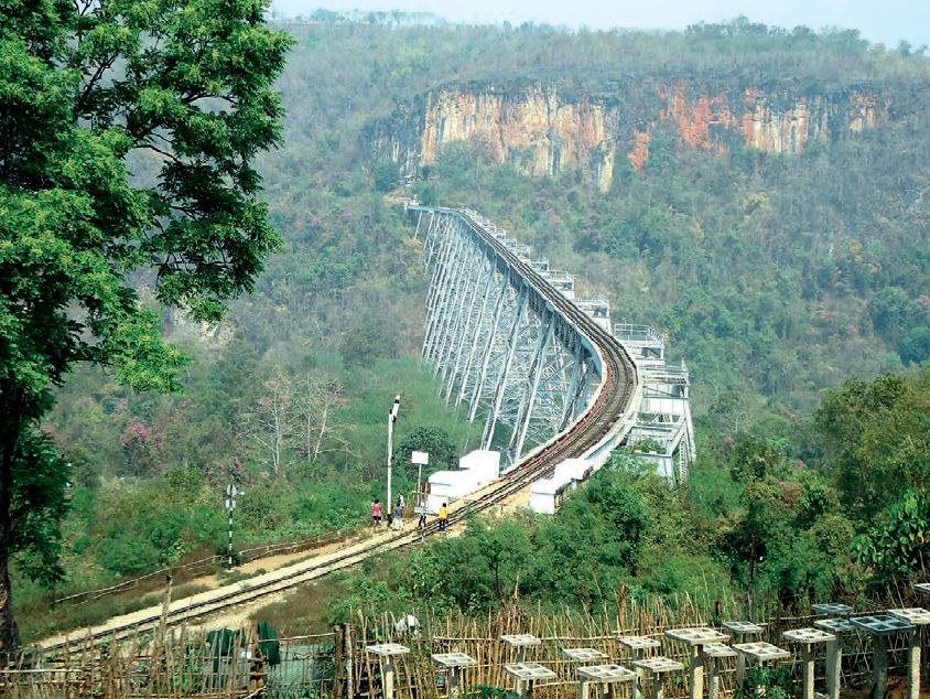
Goteik viaduct
Our second bridge is located on the trek from Mandalay to Lashio and passes over Goteik Creek (also known as Mongtin Creek) near Goteik Village in Nawnghkio Township, Kyaukme District and shares its name with both the creek and the village. The Goteik viaduct is the second highest railway trestle in the world and was constructed by the US-based Pennsylvania and Maryland Bridge Construction Company, who completed the project in 1901.
The viaduct stands 1,100 ft high, measures 2,260 ft from end to end, and includes 15 towers which span 39 ft, along with a double tower 79 ft long. It was constructed using 4,311 tons of steel and over 1 million bolts to secure it in place. The cost of construction was said to be 1,698,200 Indian rupees (around Ks 36,543,513 in today’s exchange rate).
Before passing over the landmar bridge, the train departing from PyinOoLwin will first arrive at Goteik station. The track descends from Nawnghkio station to Goteik station and travels around in magnificent curves down the mountain for an hour. Now from Goteik station, the train passes across iconic bridge, making a heart-fluttering journey for 15 minutes, before passing through tunnel 7. The tunnel is 352 ft long, 18ft high, 17.6 ft across and was burrowed into the natural rock face in 1900. The rest of the journey sees trains climbing up the mountain paths to arrive in Nawngbein station. This trip will also take over an hour to complete from start to finish.
Bent and sabotaged but still standing strong
The author was stationed at a security post on the Goteik viaduct during the 1990s, and carried out duties along the newly constructed diversionary route and along the viaduct from Goteik to Nawnghkio stations every day. It is with great joy that I am writing about the 112-year old viaduct.
The diversionary route later fell into disuse due to numerous factors, such as unsuitable earth strength to support the tracks, railway tracks curving over the designated degrees, steep climbs and descents, narrow pathways that cause wagons to collide with the rock wall, and the Goteik bailey over the creek not strong enough to support sustained train trips.
The diversionary route later fell into disuse due to numerous factors, such as unsuitable earth strength to support the tracks, railway tracks curving over the designated degrees, steep climbs and descents, narrow pathways that cause wagons to collide with the rock wall, and the Goteik bailey over the creek not strong enough to support sustained train trips.
Summary
The two bridges we’ve covered in this article are between 80 to 100 years old and incorporated with colonial architecture. Furthermore, the tunnels along the Thazi-Shwe Nyaung route and Mandalay-Lashio route are historically reported to be manmade just like the bridges and train tracks along the journey. As such, they play an important role in the region’s history and continue to be an indispensable part of the economic, social, and transportation sectors of Shan State. They should be further promoted as tourist destinations and vigorously safeguarded as historic cultural landmarks of our country.
Translated by Pen Dali


