Weather officials in Japan are warning residents of the Okinawa and Amami regions in the country's southwest to prepare for a typhoon that's bearing down on their communities.
They say Typhoon Khanun will bring violent winds, rough seas and storm surges to the regions through Wednesday.
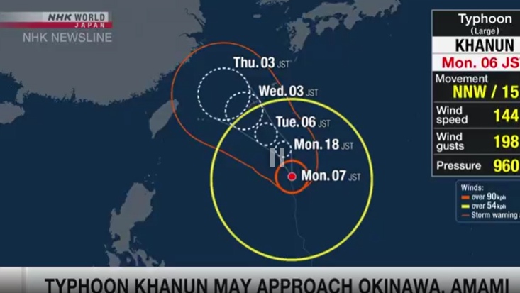
The Meteorological Agency says as of noon Monday, the typhoon was southeast of Okinawa and moving north-northwest at 15 kilometers per hour.
Conditions on islands in Okinawa Prefecture and the Amami region in Kagoshima Prefecture are becoming more windy as the storm approaches.
The typhoon is expected to move gradually westward, coming close to Okinawa and Amami through Wednesday. Its impact could be prolonged as it may slow down in the East China Sea.
Weather officials say winds across the two regions could be powerful enough to tip moving trucks on their side.
The maximum wind velocity on Monday is expected to be 90 kilometers per hour in Okinawa and 72 kilometers per hour in Amami. Peak gusts could reach 126 kilometers per hour.
The officials say on Tuesday, winds will increase to as much as 144 kilometers per hour in Okinawa, and up to about 100 kilometers per hour in Amami.
The typhoon is expected to lash both regions with torrential rain, dumping up to 150 millimeters in Amami and 100 millimeters in Okinawa in the 24-hour period to noon Tuesday.
An additional 100 to 200 millimeters is forecast for Okinawa over the following 24 hours and 100 to 150 millimeters for Amami.
The officials warn the downpour could trigger landslides, flooding in low-lying areas and swollen rivers. They say residents should also be prepared for powerful winds, as well as big waves and storm surges along the coast.
They're urging people to check their local hazard maps and take shelter in sturdy buildings before the wind and rain get stronger.
They also say residents should avoid going outside unless absolutely urgent, and stay abreast of updates from local authorities and weather officials.
xinhua


